


Weld 331, Weld County, Colorado
About
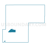
Outline

Summary
| Unique Area Identifier | 549355 |
| Name | Weld 331 |
| County | Weld County |
| State | Colorado |
| Area (square miles) | 53.48 |
| Land Area (square miles) | 52.98 |
| Water Area (square miles) | 0.50 |
| % of Land Area | 99.06 |
| % of Water Area | 0.94 |
| Latitude of the Internal Point | 40.31279050 |
| Longtitude of the Internal Point | -104.71084560 |
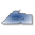
Maps


Graphs
Select a template below for downloading or customizing gragh for Weld 331, Weld County, Colorado


Neighbors
Neighoring Voting District (by Name) Neighboring Voting District on the Map
- Weld 201, Weld County, CO
- Weld 202, Weld County, CO
- Weld 231, Weld County, CO
- Weld 246, Weld County, CO
- Weld 308, Weld County, CO
- Weld 309, Weld County, CO
- Weld 311, Weld County, CO
- Weld 325, Weld County, CO
- Weld 326, Weld County, CO
Top 10 Neighboring County Subdivision (by Population) Neighboring County Subdivision on the Map
- Greeley CCD, Weld County, CO (122,755)
- Johnstown-Milliken CCD, Weld County, CO (25,317)
- Keenesburg-Hudson CCD, Weld County, CO (13,399)
- Kersey-Gill CCD, Weld County, CO (6,033)
- La Salle-Gilcrest CCD, Weld County, CO (4,653)
- Platteville CCD, Weld County, CO (4,222)
Top 10 Neighboring Place (by Population) Neighboring Place on the Map
- Evans city, CO (18,537)
- Milliken town, CO (5,610)
- La Salle town, CO (1,955)
- Gilcrest town, CO (1,034)
Top 10 Neighboring Unified School District (by Population) Neighboring Unified School District on the Map
- Greeley School District 6, CO (114,372)
- Johnstown-Milliken School District RE-5J, CO (16,550)
- Weld County School District RE-1, CO (8,930)
- Platte Valley School District RE-7, CO (4,697)
Top 10 Neighboring State Legislative District Lower Chamber (by Population) Neighboring State Legislative District Lower Chamber on the Map
- State House District 48, CO (112,104)
- State House District 50, CO (78,392)
- State House District 65, CO (77,293)
Top 10 Neighboring State Legislative District Upper Chamber (by Population) Neighboring State Legislative District Upper Chamber on the Map
Top 10 Neighboring 111th Congressional District (by Population) Neighboring 111th Congressional District on the Map
Top 10 Neighboring Census Tract (by Population) Neighboring Census Tract on the Map
- Census Tract 21.01, Weld County, CO (7,319)
- Census Tract 10.05, Weld County, CO (6,459)
- Census Tract 25.02, Weld County, CO (5,656)
- Census Tract 17, Weld County, CO (4,653)
- Census Tract 16, Weld County, CO (4,346)
- Census Tract 18, Weld County, CO (4,222)
- Census Tract 14.04, Weld County, CO (2,613)
- Census Tract 7.05, Weld County, CO (1,541)
Top 10 Neighboring 5-Digit ZIP Code Tabulation Area (by Population) Neighboring 5-Digit ZIP Code Tabulation Area on the Map
- 80634, CO (52,861)
- 80620, CO (17,775)
- 80543, CO (5,887)
- 80651, CO (4,176)
- 80645, CO (3,905)
- 80644, CO (2,989)
- 80623, CO (1,028)